
|

|

|

|

|

|

|

|

|

|

|

|
The Drawings of Eduard Harkort - 1836
Eduard Harkort (also spelled as Edward Harcourt) was an interesting fellow. He was born to an industrialist family near Hagen, Kingdom of Prussia (now North Rhine-Westphalia, Germany) in 1797. After working as a surveyor and in his father's steel-making business, and even serving a stint in a Prussian artillery regiment, he was educated in mineralogy and mining at the Royal Mining Academy at Freiburg, Saxony. He was hired by a British mining firm to oversee their mining and smelting operations in Mexico, and arrived there in 1828. In 1832, he became involved in politics, joining Santa Anna's revolutionary forces as a Captain, but was imprisoned after a first unsuccessful battle, eventually escaping and then serving as Colonel of Artillery. Later, turning against Santa Anna, he was imprisoned yet again, eventually being deported to New Orleans in Nov-1835. There, he met Stephen F. Austin, who convinced him to join the incipient revolution in Texas, and Harkort was appointed chief engineer of the Texas Revolutionary Army in March-1836. He spent the remaining spring and summer at Velasco and Galveston, building fortifications to protect Texas from Mexican invasion by sea. Tragically, he died of a fever near San Jacinto Bay in Aug-1836.
Eduard Harkort (also spelled as Edward Harcourt) was an interesting fellow. He was born to an industrialist family near Hagen, Kingdom of Prussia (now North Rhine-Westphalia, Germany) in 1797. After working as a surveyor and in his father's steel-making business, and even serving a stint in a Prussian artillery regiment, he was educated in mineralogy and mining at the Royal Mining Academy at Freiburg, Saxony. He was hired by a British mining firm to oversee their mining and smelting operations in Mexico, and arrived there in 1828. In 1832, he became involved in politics, joining Santa Anna's revolutionary forces as a Captain, but was imprisoned after a first unsuccessful battle, eventually escaping and then serving as Colonel of Artillery. Later, turning against Santa Anna, he was imprisoned yet again, eventually being deported to New Orleans in Nov-1835. There, he met Stephen F. Austin, who convinced him to join the incipient revolution in Texas, and Harkort was appointed chief engineer of the Texas Revolutionary Army in March-1836. He spent the remaining spring and summer at Velasco and Galveston, building fortifications to protect Texas from Mexican invasion by sea. Tragically, he died of a fever near San Jacinto Bay in Aug-1836.
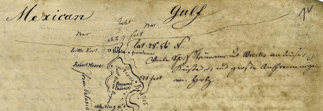
Detail from upper portion of first Harkort drawing, showing mouth of Brazos River with "Little Fort" and "Batterie"
In the 1990's, it was discovered that Eduard Harkort had sent his journal about Texas to his family in Germany, which included ten drawings of southeast Texas in that critical period of the Texas Revolution in 1836. The journal was translated and published (in 1999) by Professor of German Louis E. Brister of Southwest Texas State University, who had been studying Harkort and had published earlier works about him. In Brister's publications, the drawings are low-resolution, and in black and white. In Jul-2020, based on Prof. Brister's leads, the archive holding Harkort's journal was contacted to see if they might provide high-resolution photo duplicates of the ten drawings. They graciously agreed, under the condition that they be used for research and educational purposes only, and that they be cited as to their origin:
"Tagebuch Eduard Harkorts (Fragment), 1836, Stiftung Westfälisches Wirtschaftsarchiv, Dortmund, N 7/47 Nr. 2 (and 3)"
So, we are pleased to display these wonderful and magnificently informative drawings below, as medium-resolution images, under the premise that they be considered copyrighted by the German archive in Dortmund, and that any commercial use or publication be arranged with them.
Note: Many of Harkort's drawings do not use North for the top of the map
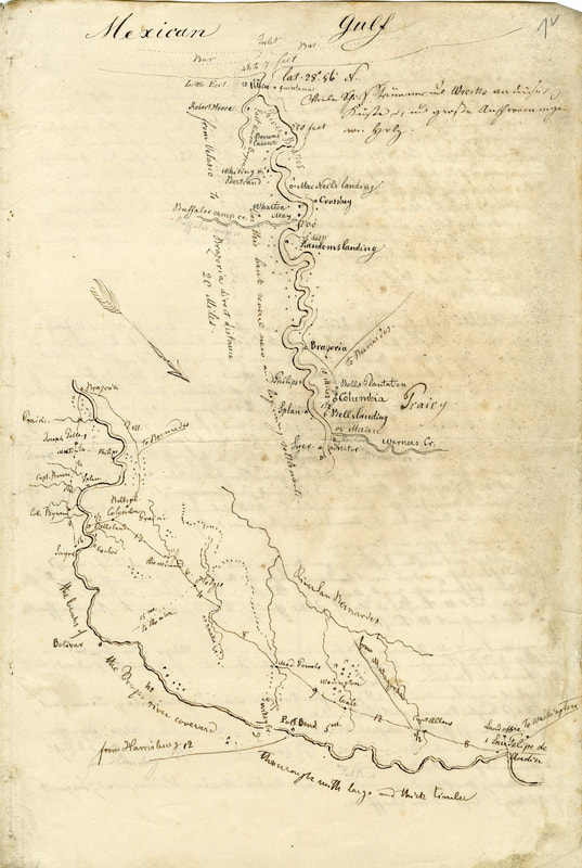
Map of Brazos River with Settlements from San Felipe de Austin to the Mexican Gulf (back of page 1 of journal)
|
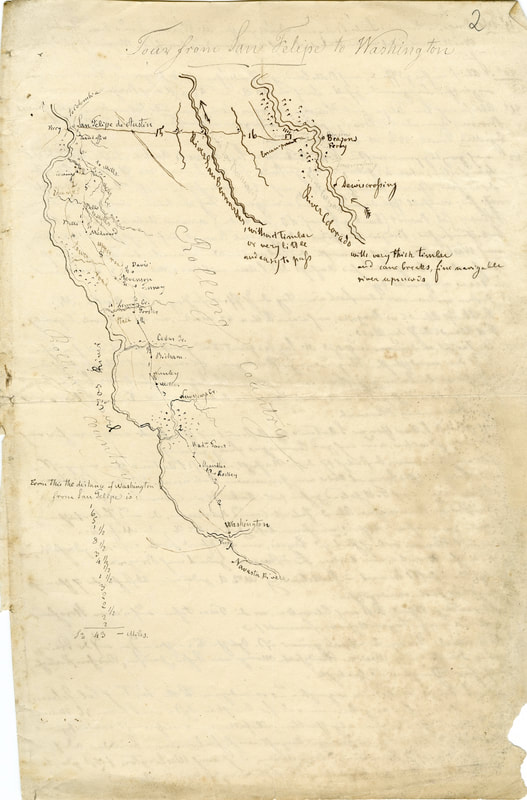
Map of "Tour from San Felipe to Washington"
(front of page 2 of journal) |
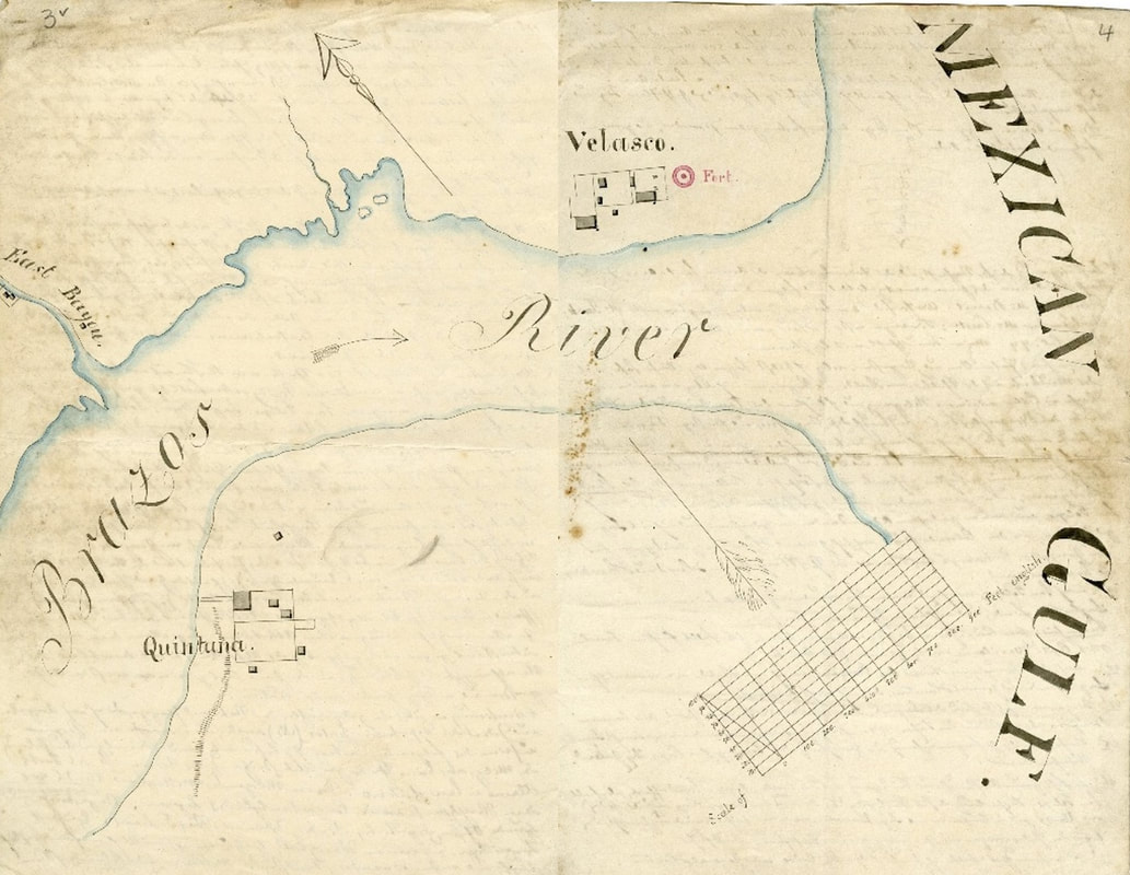
Electronically spliced images of "Map of Brazos River with East Bayou and Quintana" and "Map of Mouth of the Brazos River on the Mexican Gulf with Velasco and the Adjacent Fort" (back of page 3 and front of page 4; apparently one drawing at first, then cut and pasted into journal)
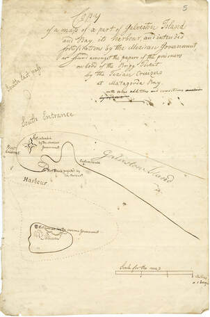
"Copy of a map of a part of Galveston Island and Bay, its harbour, and intended fortifications by the Mexican Government, as found amongst the papers of the prisoners on bord of the Brigg Pocket by the Texan Cruisers at Matagorda Bay, with some additions and corrections" (front of page 5)
|
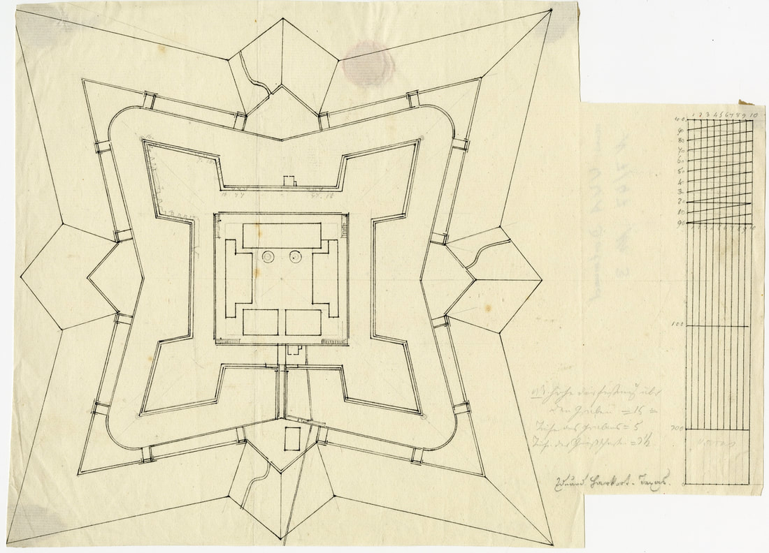
Eduard Harkort's original plans for the construction of Fort Travis
(Zeichnungen und Gemalde N 7/47 Nr. 3; first item) |
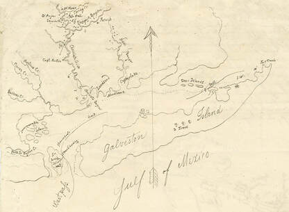
Map of Galveston Island with adjacent creeks, bayous, and islands (front of page 6)
|
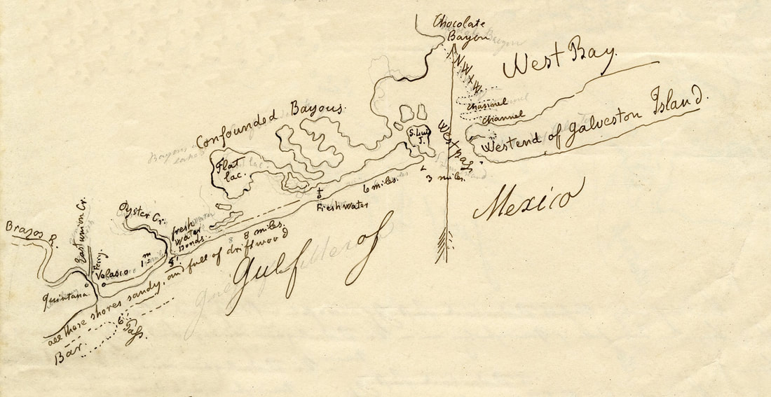
Map of Texas coastline from the mouth of the Brazos River to the west end of Galveston Island, with Confounded Bayous and West Bay (back of page 6)
|
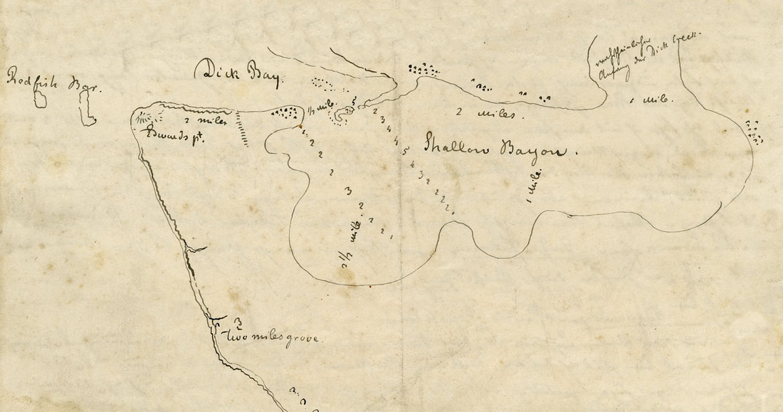
Map of Shallow Bayou (mouth of Dickinson Bayou) with Red Fish Bar and Dick (Dickinson) Bay (back of page 7) - current San Leon, Texas and Edwards Point
|
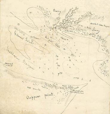
Map of Clopper's Point (current Morgan's Point) and Spillman's Island with Shallow Bayou and Rolling Prairy (front of page 8)
|
Publications about Eduard Harkort:
Louis E. Brister, "Colonel Eduard Harkort: A German Soldier of Fortune in Mexico and Texas, 1832-1836", SWHQ, 88 (Jan-1985), pp. 229-241
Louis E. Brister, In Mexican Prisons: The Journal of Eduard Harkort, 1832-1834 (College Station: Texas A&M University Press, 1986)
Louis E. Brister, "The Journal of Col. Eduard Harkort, Captain of Engineers, Texas Army, February 8-July 17, 1836", SWHQ, 102 (Jan-1999), pp. 344-379
A narrative report that discusses all of the research on
the several Forts Velasco is available at the link below:
Chronological and Archaeological History of the Forts Velasco
<<< The Texan Fort Velasco < click for other pages > Velasco as Seat of Government >>>
Background wallpaper is from 1834 version of "Map of the State of Coahuila and Texas" by William Hooker of New York
Background wallpaper is from 1834 version of "Map of the State of Coahuila and Texas" by William Hooker of New York
