
|

|

|

|

|

|

|

|

|

|

|

|
Civil War Forts (1861-1865)
|
During the Civil War, a series of artillery positions were constructed by the Confederate States Army, changed and improved over time, beginning with a simple earthen redoubt of two 18-pound cannons (known as the "Town Redoubt” or “Town Fort”), probably on new beachfront land closer to the gulf than the position of the former Republic Of Texas battery. The redoubt was manned by two artillery companies belonging to the Thirteenth Texas Infantry regiment, utilizing at least one eighteen-pound cannon on 11-Aug-1862 to drive off a Union warship. The location of this redoubt is shown in a large hand-drawn map of the central Texas coast by Confederate Army Capt. Tipton Walker from the early Civil War era. A close-up of the Velasco portion is shown to the right. The location of Monument Square is marked in this map by a tent-like image, perhaps indicating an encampment used by soldiers in the early part of the war.
The fort shown on this map and an artist's rendition (below) is apparently the one described by Commodore Henry Haywood Bell aboard the USS Brooklyn in his diary entry of 1-Jun-1863 – “Saw in the river at Velasco one steamer and one schooner. A newly-built fort on the Quintana side, and 100 tents adjacent ... On the Velasco side the battery is not so prominent; situated near the water and to the south of the white house with colonnades, some 40 or 50 men there in the rear of the fort.” |
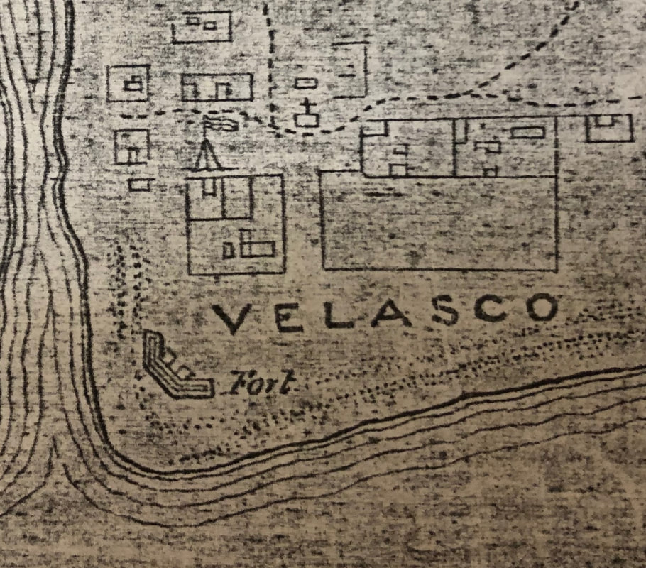
Velasco portion of Tipton Walker map, circa 1862
map from National Archives |
"Town Fort" or "Town Redoubt" built circa 1861
drawing courtesy of Brazoria County Historical Museum |
The “white house” is presumed to be the Archer-Herndon House (L-shaped structure in map above). In 1932, Mrs. T. A. Humphries wrote “On a sandy ridge in the neighborhood of the coast guard station, stands a clump of gnarled salt cedars and the crumbling ruins of a huge brick cistern. They are all that remains of the palatial summer home of the Herndons ... this spot was occupied by a stately white mansion, surrounded by wide porches and supported by solid colonial columns. It was the tallest house along the coast and could be seen so far at sea that it became a landmark. It stood on the highest point of land and was used as a lookout by the neighborhood. .... The house was surrounded by salt cedars and oleanders. Hidden among the shrubbery was an icehouse with concrete walls. In the spring of each year, a shipload of ice was brought from the north, carefully packed in sawdust, and stored for their use in the summer. ... In order that enemy ships should not enter the Brazos, the Confederate soldiers barred the channel with live oak logs driven into the bottom of the stream.” This original Archer-Herndon house was reported as destroyed in the 1875 hurricane. |
|
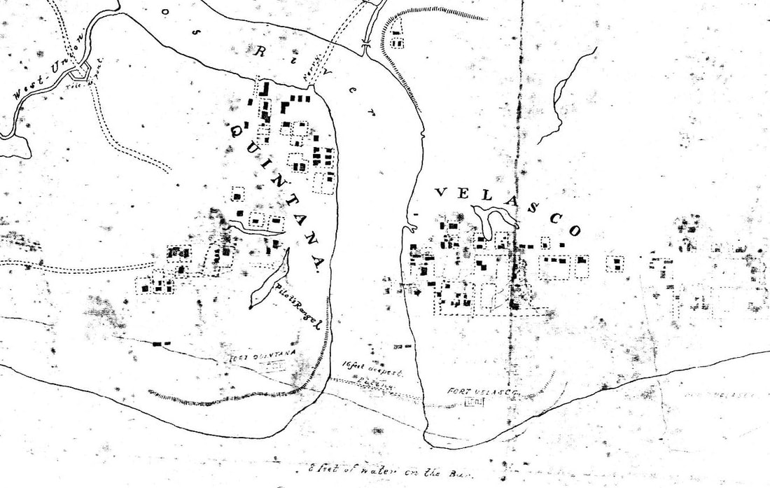
Another map drawing is found in the U.S. National Archives (right) which depicts that a similar early fort was constructed on the Quintana side, and that a row of pilings was constructed across the mouth of the Brazos River between these two forts. The British-flagged schooner Rob Roy had run the blockade into the Brazos in Sep-1863 looking for a load of cotton, and was commandeered by the Confederates for a few weeks to install the pilings. This circa-1863 map also shows a ferry crossing from Quintana over the Brazos to a road along East Union Bayou and canal (labeled as “Covered Way”) leading to a structure at the canal crossing northeast of Velasco marked as Téte de pont, a term for a military work to protect a bridge. A similar structure is shown on the road over West Union Bayou into Quintana. This map also reveals the fort at Velasco was labeled as "Fort Velasco". 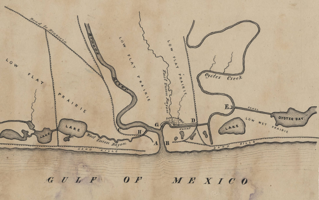
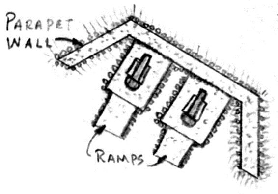
The position marked as B was the site of a new formal five-gun-platform fortification known as Fort Sulakowski or Fort Velasco (see drawing to right), completed in the winter of 1863-1864 adjacent to the town, and at a location a bit further upstream from the "Town redoubt". Armament consisted of one 30-pound Parrot gun, one 32-pounder Navy gun, one 24-pound and one 18-pound Sea coast guns, and one 12-pounder. So effective was this battery that blockading Union warships estimated in early 1864 that it had six 32-pounders, and never engaged them for any period of time. The fort was built under the supervision of Lt. Abram Cross for his commander, Valery Sulakowski (who designed it), then Chief Engineer for the Confederate States Army for the District of Texas, New Mexico and Arizona. The fort was labeled as Fort Sulakowski in one of Cross’ reports where he reported completion on 11-Jan-1864 – see drawing on Home page. The Velasco fort complex was but one of three such forts built at or near the Brazos River mouth in this period, and similar Civil-War-era forts existed across the river at Quintana (Fort Bates, A) and about a mile upriver (Fort Terrell, also known as Fort Bend, C); this last site being thought lost due to riverbank erosion in the 65 years after its founding. About five miles upstream, a floating barrier of live-oak logs was also erected across the river, originally guarded by a battery of two 8-inch siege howitzers on the right bank; however, a second battery of two 12-pound siege guns were added on the left bank. |
Due to the strategic importance of the Brazos River for blockade runners, work at Velasco eventually resulted in an entire series of forts, emplacements, roads and bridges protecting the area around the mouth of the river in the period of late 1863 to early 1864, as shown in a diagram found in the Gilmer Civil War Map Collection at the University of North Carolina at Chapel Hill (left). In this diagram, the position of each work is denoted with a letter. It reveals unmanned fortifications included a Redoubt at the canal crossing (D), a redan at Oyster Creek (E) and a floating swing bridge (G). 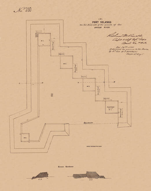
Fort Velasco or Fort Sulakowski, built 1863-1864
|
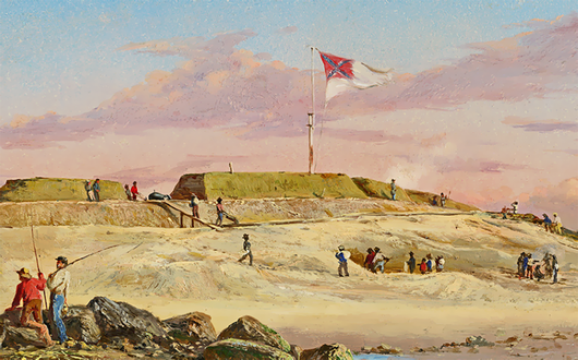
Fort Moultrie artwork by Conrad Wise Chapman
(from website at https://deadconfederates.com/tag/valery-sulakowski/) |
These forts were thick stacked-earth embankments topped with sod, with the guns en barbette, since brick forts (such as Fort Sumter or Fort Pulaski) were by-then considered obsolete. The Velasco forts resembled Fort Moultrie in coastal South Carolina, an area where Valery Sulakowski had worked earlier in the war (an artist rendition is shown to the left). It is also reported that, during this time, the large number of Confederate troops at Velasco scavenged material from the nearby site of the 1832 fort. A more formal map was prepared by Capt. Tipton Walker in 1864 for the entire coast of Texas (below) showing many of the forts defending the coast. The Brazos forts are shown in minor detail in an inset in the upper right corner. These forts are also featured in newer drawings inspired by this 1864 map in the book "Texas In The Confederacy – Military Installations, Economy and People" by Bill Winsor. |
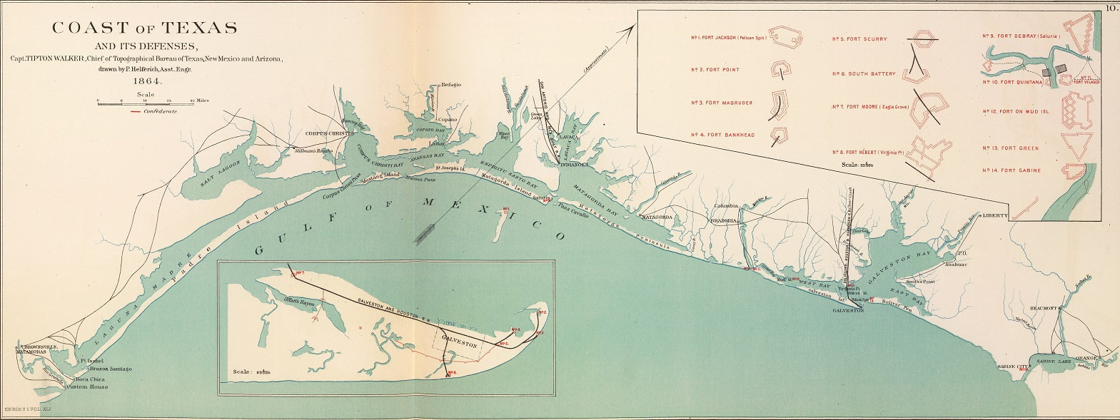
Map of "Coast of Texas and its Defenses" by Tipton Walker, 1864
A narrative report that discusses all of the research on
the several Forts Velasco is available at the link below:
the several Forts Velasco is available at the link below:
Chronological and Archaeological History of the Forts Velasco
<<< Velasco as Seat of Government < click for other pages > Tipton Walker Maps >>>
Background wallpaper is from 1836 version of "Map of Texas - With Parts of the Adjoining States" by Stephen F. Austin, printed by H. S. Tanner of Philadelphia
Background wallpaper is from 1836 version of "Map of Texas - With Parts of the Adjoining States" by Stephen F. Austin, printed by H. S. Tanner of Philadelphia
