
|

|

|

|

|

|

|

|

|

|

|

|
What was "Monument Square"?
What was being commemorated in 1837 at Velasco?
What was being commemorated in 1837 at Velasco?
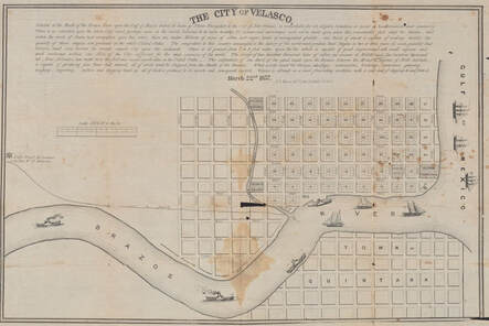
Photo image of orginal Mesier 1837 Plat Map of Velasco
from Beinecke Library, Yale University |
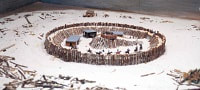
A plat map for the envisioned town of Velasco was created by the lithography firm of Peter A. Mesier & Co. (of 28 Wall Street, New York, NY) dated 12-Mar-1837 (left), probably at the behest of the Velasco Association (a group of land speculators and developers) . In this map, the approximate location of the 1832 fort is marked with an unnumbered block entitled "Monument Square", obviously intended for some type of public use. A few other unnumbered blocks are also marked for public use such as "Church Square", "College Square" and "Bonham Promenade". Most blocks are numbered, and typically have 8 or 10 lots numbered within each block. Block 61 is marked with an image labeled as "Battery", which appears to be the artillery emplacement created in early 1836 during the Texas Revolution, which was occupied until at least 1840 (.... more on that on a later page). |
|
A close-up detail from this map is shown to the right, indicating the area at the corner of the Gulf and the Brazos River. The up-down streets flanking Monument Square are named as Custom Street and Fort Street. The left-right streets bordering it are First Street (bottom side, in this view) and Second Street (top side). To the right of Monument Square is numbered Block 13, indicating it was divided into 10 lots, up the right side and then down the left side of the block (in this view).
There are two main hypotheses about what Monument Square was commemorating. The first hypothesis is that it marked the location of the 1832 Mexican fort and/or the Texian victory achieved in the Battle of Velasco. This hypothesis can most prominently be seen today in the final reports of two in-depth archaeological surveys, one done in 1980 by the Center for Archaeological Research (UTSA) and another in about 1992 by Prewitt & Associates (reports published in 1981 and 1996, respectively). There is really no direct evidence this is the case, but it is a reasonable hypothesis, and a published broadside on the first anniversary of the battle (below) may give us some cause to support this first hypothesis. The second hypothesis is that Monument Square instead represents the area where at least some of the Texian dead from the Battle of Velasco (perhaps numbering 10-12) were buried. In this battle, one division of the Texians under John Austin and Henry Smith dug trenches during the night north of the fort, and suffered the bulk of the casualties, since they had the misfortune to suffer from a swivel gun mounted on the north wall which was displayed with deadly effect by the Mexican troops. Were the dead buried where they fell, and is Monument Square a place to dedicate their graves? |
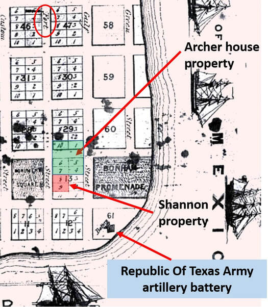
Close-up detail of the 1837 Mesier Plat Map of Velasco
Courtesy of Brazoria County Historical Museum |
We also know from Ugartechea's after-action report that the Mexican dead were also buried in the vicinity of the fort. Secondly, The Arkansas Advocate newspaper on 6-Feb-1833 published some proceedings of a meeting at San Felipe de Austin in late 1832, under the headline “”Monument – (to be erected at the mouth of the Brazos River”, with the words “In all civilized countries, and ages, the chivalric deeds of the brave, have been commemorated, not only in history and song, but by lasting monuments erected on the spot where their imperishable glory was achieved. In the infancy of a country, these mementos of the bravery of her sons – should never be neglected. They constitute the records of renown; and when connected with Liberty, they should be hoarded as a rich and sacred treasure. Even the remains of such spirits should be treated with that respect, to which their heroism and courage entitled them – there should be something to point out the spot where their ashes lie, and say ‘Here rests the Brave’.” The article then gives specific details for the MONUMENT (maybe in Monument Square!). Thirdly, in 1838, Mary Austin Holley wrote in her diary “We crossed over to Velasco. Went shopping (they have one store), visited the Archer House, a fine hotel. Large 2 story with gallery painted, white, looks well. Had a commanding view. Met with Gen. Green (Thomas Jefferson Green) the master spirit here who attended us in our walk – pointed to the graves of those who fell in the first battle for Independence – looked at the old fort – the work of the Mexicans – Velasco looks like quite a place.” These three references all indicate that the fatalities were buried nearby.
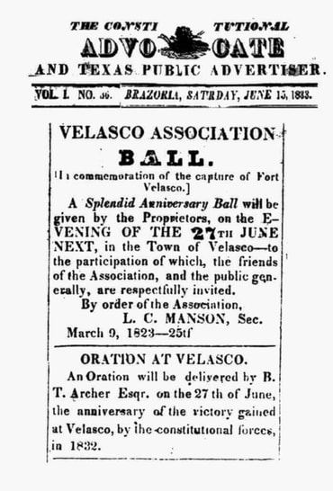
Broadside published on first anniversary of Battle Of Velasco
Courtesy of Brazoria County Historical Museum |
There are further clues, to support the second hypothesis, in that the information suggests the 1832 fort was elsewhere.
In about 1838, the Velasco Association built a two-story structure as a hotel, which they named the "Archer House", in honor of Branch T. Archer. Deed records indicate this property was supposed to be in Lots 4-7 of Block 13. However, perhaps due to incorrect surveying of the time, this structure was later found to have been partially built atop an area platted as Second Street next to Lots 5 and 6. Subsequently, the owners of Lots 1 and 10 in the adjoining Block 29 had to give up their property to re-establish the street, and the former street path became a de-facto part of the Archer House property (see green area in diagram above). In 1845, the property involving the Archer house (Lots 4, 5, 6 and 7 of Block 13 and Lots 1 and 10 of Block 29) was sold with the comment “... all that certain parcel of property lying and situated in the Town of Velasco known as the ‘Archer House’ with the four lots immediately adjoining said ‘Archer House’ and not including the two lots near what was called the ‘Old Fort’.” - see image of original below. Since the Republic Of Texas battery was located in Block 61, this seemingly can only refer to the 1832 fort. Lots 4 and 7 were on the river side of the Archer House, so may have been the ones not sold, and may be nearest the “Old Fort”. The “Archer House” was bought in 1855 by John H. Herndon, and was known afterwards as the “Archer-Herndon House” or simply the “Herndon Beach Home”, becoming a prominent local landmark. |
|
Lots 8 and 9 of Block 13 were purchased by James Thompson Shannon in 1856, immediately adjacent to Lot 7 (see pink area in diagram above right). A house was already existing on the property, sometimes named after its original owner (Lewis Lapoleon), but subsequently known as the Shannon house.
In 1898, Adele B. Looscan (1848-1935) published a seminal article entitled “The Old Mexican Fort at Velasco”, apparently after interviewing several life-long residents of the area. In this article, the second wife of James T. Shannon (Mrs. Ellen Adele Wilcox Shannon) claimed her residence (in Lots 8 and 9 of Velasco Block 13, fronting on the southeast side of Fort Street) as the sight of the Mexican fort. Mr. Alexander Glass Follett, Sr. (1822-1906) agreed, and also added that Mrs. Shannon’s house was newly-built in 1887, after the previous structure was damaged in the 1886 hurricane. Thus, it would seem that we have two contemporaneous accounts that the 1832 Mexican fort was located, not in Monument Square, but in the west side of Block 13, which was at the foot of Fort Street. The area due north of this location, where the Texians took many casualties, is located within Monument Square. Thus, the author of this website tends to favor the second hypothesis, especially since a recent Geophysical Survey seems to confirm the 1832 fort is where Mrs. Shannon said it was (currently in Surfside Block 568): see report. |
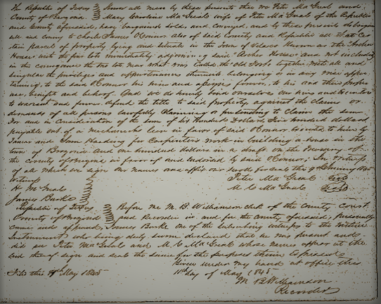
Photo duplication of original 1845 MacGreal-O'Connor deed for sale of Archer House
|
A narrative report that discusses all of the research on
the several Forts Velasco is available at the link below:
A narrative report that discusses all of the research on
the several Forts Velasco is available at the link below:
Chronological and Archaeological History of the Forts Velasco
<<< Weapons at the Battle of Velasco < click for other pages > The San Felipe Incident >>>
Background wallpaper is from 1836 version of "Map of Texas - With Parts of the Adjoining States" by Stephen F. Austin, printed by H. S. Tanner of Philadelphia
Background wallpaper is from 1836 version of "Map of Texas - With Parts of the Adjoining States" by Stephen F. Austin, printed by H. S. Tanner of Philadelphia
